Welcome to the Toutle Valley!
I'm starting this blog to help visitors find the many things to do around Mount St. Helens and the Toutle Valley. Our area is surrounded by adventure, high and low, but it's sometimes genuinely hard to find information about these special places. Before our volcano erupted, the Spirit Lake Hwy followed the Toutle River all the way to Spirit Lake and Mount St. Helens with easy-to-find adventure around every bend. The route was lined with campgrounds, river access, logging roads, trails open to all, and vast areas to explore.
Today its different--With all the passes, permits, and rules, it's a tangle of red tape to just understand where you can go for a walk. Don't dispair! I know all the secrets... and I might even be asking for your help to make the area more accessible.
Consider this blog your Insider's Guide to the Toutle Valley.
|
May 4, 2026 12:43:07
Posted By Toutle Trekker
|
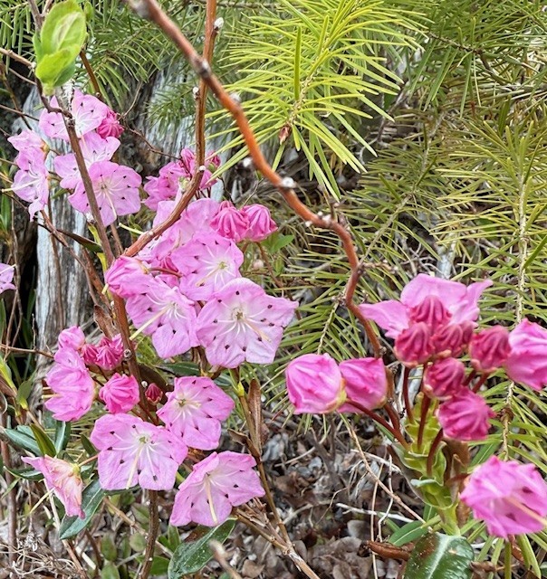
Last year while slogging around the Toutle State Forest in search of elk sheds and unique birds, I discovered a little gem of a swamp (and a saw-whet owl). As a trained botanist, I noticed the unique character of the wetland, with bog laurel, peat moss, abundant shrubs rimmed by remnant old growth and snags. Unfortunately, the whole wet meadow was crisscrossed with ATV tire tracks and mudder abuse. The DNR had tried pit traps, signs, and other barriers to keep slobs out of this special area to no avail. One spring day, I was there when a side-by-side came putting right through the center of the meadow, tearing up the unique plants and leaving a long-lasting scar. When confronted, the folks in the UTV couldn't believe they were doing anything wrong. I guess they figured the barriers the DNR had dug to try to keep out motorized vehicles did not mean them. Now the DNR has designated 166 acres of this wetland and some of surrounding land as the Toutle Ridge Fen Nature Area Preserve. The designation should give the DNR more options to enforce the "no motorized vehicles" policy. (Oddly, the DNR logged part of what is now 'protected forever' just last year.)
|
|
May 4, 2026 11:49:46
Posted By Toutle Trekker
|
I've started to exploring the Hoffstadt Hills property, a new addition to the state-owned St. Helens Wildlife Area. This new public acquisition provides an instant boost for hiking, dog walking, and bicycling on ready-made 'trails' aka old logging roads. The property contains at least 2 miles of trail/roads that provide a great place to birdwatch, stretch the legs, or access the mudflow area. The main route parallels the Spirit Lake Highway. The grades are gradual, the roads recently maintained, and the substate is pretty smooth for walking and would work for bicycles or even some strollers. This strip of property connects with Ecopark Resort on the west and Havilah Retreat (the former Hoffstadt Visitor Center) on the east, and the Department of Wildlife Mudflow Unit to the south. More hiking opportunities on old roads and unofficial trails are available once on the Mudflow Unit (that area was closed to protect wintering elk until May 1). Park near the gate where the access road drops toward the mudflow. Currently the land is not signed as public land, but the Weyerhaeuser signs have been removed.
|
|
April 19, 2024 08:43:44
Posted By Toutle Trekker
|
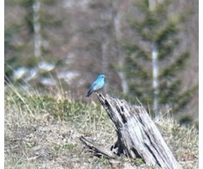
Yesterday I visited Johnston Ridge. How, you ask? The road to the top is washed out and will be closed for YEARS. True, but you can still hike there on the Boundary Trail. Start at the Hummocks Trail near the information board. This loop trail intersects with the west end of the 65 mile long Boundary Trail, which takes off toward Johnston RIdge. Look for the wooden trail sign near an interpretive panel overlooking a meadow near some ponds. Take this trail. It is a 4 mile hike UP the ridge. I climb this several thousand feet each spring to get in shape for the summer season. The snow is nearly gone now, and the main difficulty is some outsloped tread that passes above cliffs and loose rocks. Use hiking poles and have good boots. This is not a beginner trail! After the first big climb you will be on an open ridge that was a clearcut before the eruption. You can tell because of all the rotting stumps sticking out above the ash. This is where the bluebirds live. Look for their sky blue plumage and listen for their charming songs. I saw nearly 30 bluebirds in the area and I took some photos. For an extra treat, on the steep adjacent hillside a family of seven mountain goats were browsing and romping. Beautiful. The sky was the same color as the bluebirds, and the goats matched the snow on Mount St. Helens and the Mt. Margaret Backcountry. I turned around at the Loowit Viewpoint. Round trip took about four hours, nearly 8 miles, and 2000 foot elevation gain. Watch out for those steep, angled sections of trail.
|
|
July 10, 2023 09:20:48
Posted By Toutle Trekker
|
These are Toutle Trekker's top 5 Spirit Lake Highway Hikes.
Best with Children: Seaquest Park. The mile or so wetland stroll along the Silver Lake Boardwalk is a great way to share nature with little ones. The surface is stroller compatible and offers great birdwatching, bugwatching, and listening to nature (including bullfrogs). For a longer walk, the tunnel under the road to Seaquest Park trails and playground is fun, too. Park the the Mount St. Helens Visitor Center or at Seaquest Park.
Best Day Hike: Hummocks Trail. A two mile loop through the land that was once the summit of Mount St. Helens, complete with many ponds filled with life and peek-a-boo views of the volcano. The Hummocks Trailhead is currently as far as you can drive.
Best Long Hike: Coldwater Loop. With the road still closed to the South Coldwater Trail, so start at the hummocks parking lot, walk the road to the South Coldwater Trailhead then climb to the blasted logging equipment. Keep going looping up to the Coldwater Trail, then drop to down toward the lake. Connect with the Lakes trail and fish your way back to the Coldwater Lake parking area. A short road walk completes this day-long loop (about 13 miles)
Best 'Secret' Hike: Green River junction. Heading east, just past Sediment Dam Road, cross the North Toutle River then look for a wide spot on the left with a green gate on a closed road. Park here and follow angler trails to the junction of the Green and North Toutle. A bit of bushwhacking may be required. Bring your license and fishing rod and regulations! Another secret hike takes you across the sediment dam. Follow Sediment Dam road to the large trailhead. This is a great place to view elk and waterfowl in the winter.
Best 'In Town' Hike: Top the Rock in Castle Rock. Start at the trailhead at the entrance to town. Follow the path along the Cowlitz River, past the bike skills park, and end at the then take the gravel trail to "Top the Rock". Turn around or end at Lions Pride Park.
|
|
May 5, 2022 09:14:08
Posted By Toutle Trekker
|
Yesterday evening my family drove up the Spirit Lake Highway to check out the snow level and go for a hike up the ridge. The snow is deeper than it was a month ago, but we did hike up the the logging equipment on the South Coldwater Trail. What a treat! We were the only people up on the ridge at this time, and the animals were out everywhere. We saw, on the drive and hike, nearly 200 elk. The elk must be migrating up from the valley to the ridges toward the snowline. Of all the elk we saw moving, only one bull was limping, a sign of "hoof rot disease" that is plaguing our herds. The sooty grouse (aka blue grouse) were whooting and whopping all around. Often they are heard but not seen. I did track down and watch two roosters strutting their stuff. The violet-green swallows and yellow-rumped warblers were back for the summer. A pack of coyotes yipped down by the lake, and a pair of black-tailed deer watched us trek by. Of all this wild activity, the highlight of the hike was the beautiful, shiny black bear that we watched as it wandered down an old road. The bear would stand up on its hind legs and scratch its back on alder trees. It had been hunting ants and winter killed carcasses, no doubt, and we found where it tore into an ant hill by the trail.
Wildlife Viewing Pointers: Hike in the morning or evening on a non-weekend day, stay quiet and keep alert, listen for wildife which are often heard before they are seen, and don't forget binoculars (like we did). All these critters are spooky, so don't get too close, just watch quietly.
|
|
|
|