Welcome to the Toutle Valley!
I'm starting this blog to help visitors find the many things to do around Mount St. Helens and the Toutle Valley. Our area is surrounded by adventure, high and low, but it's sometimes genuinely hard to find information about these special places. Before our volcano erupted, the Spirit Lake Hwy followed the Toutle River all the way to Spirit Lake and Mount St. Helens with easy-to-find adventure around every bend. The route was lined with campgrounds, river access, logging roads, trails open to all, and vast areas to explore.
Today its different--With all the passes, permits, and rules, it's a tangle of red tape to just understand where you can go for a walk. Don't dispair! I know all the secrets... and I might even be asking for your help to make the area more accessible.
Consider this blog your Insider's Guide to the Toutle Valley.
|
July 13, 2026 06:35:09
Posted By Toutle Trekker
|
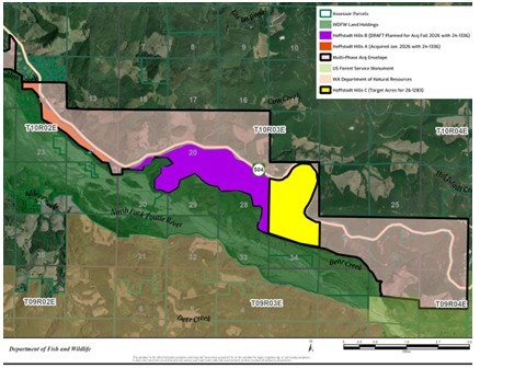
After its first successful purchase of about 200 acres, the WDFW has some leftover money to buy more--if Weyerhaeuser is willing to sell. They are also trying for a new Hoffstadt Hills grant. The plan is to gradually purchase the private land between the Spirit Lake Highway and the mudflow. They also have outlined an area that crosses to the north of the highway. I think there is probably a spotted owl nest near Hoffsadt Bridge on the north side of the highway because there is a patch of old timber there that has not been logged, and there is absolutely no other reason for Weyerhaeuer to let it live this long. In the graphic, the orange strip has been purchased, and the WDFW is currently pursuing the purple and yellow, but anything shaded within the black line could be acquired.
|
|
May 4, 2026 11:49:46
Posted By Toutle Trekker
|
I've started exploring the Hoffstadt Hills property, a new addition to the state-owned St. Helens Wildlife Area. This new public acquisition provides an instant boost for hiking, dog walking, and bicycling on ready-made 'trails' aka old logging roads. The property contains at least 2 miles of trail/roads that provide a great place to birdwatch, stretch the legs, or access the mudflow area. The main route parallels the Spirit Lake Highway. The grades are gradual, the roads recently maintained, and the substate is pretty smooth for walking and would work for bicycles or even some strollers. This strip of property connects with Ecopark Resort on the west and Havilah Retreat (the former Hoffstadt Visitor Center) on the east, and the Department of Wildlife Mudflow Unit to the south. More hiking opportunities on old roads and unofficial trails are available once on the Mudflow Unit (that area was closed to protect wintering elk until May 1). Park near the gate where the access road drops toward the mudflow. Currently the land is not signed as public land, but the Weyerhaeuser signs have been removed.
|
|
April 19, 2024 08:43:44
Posted By Toutle Trekker
|
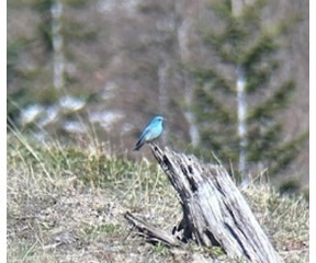
Yesterday I visited Johnston Ridge. How, you ask? The road to the top is washed out and will be closed for YEARS. True, but you can still hike there on the Boundary Trail. Start at the Hummocks Trail near the information board. This loop trail intersects with the west end of the 65 mile long Boundary Trail, which takes off toward Johnston RIdge. Look for the wooden trail sign near an interpretive panel overlooking a meadow near some ponds. Take this trail. It is a 4 mile hike UP the ridge. I climb this several thousand feet each spring to get in shape for the summer season. The snow is nearly gone now, and the main difficulty is some outsloped tread that passes above cliffs and loose rocks. Use hiking poles and have good boots. This is not a beginner trail! After the first big climb you will be on an open ridge that was a clearcut before the eruption. You can tell because of all the rotting stumps sticking out above the ash. This is where the bluebirds live. Look for their sky blue plumage and listen for their charming songs. I saw nearly 30 bluebirds in the area and I took some photos. For an extra treat, on the steep adjacent hillside a family of seven mountain goats were browsing and romping. Beautiful. The sky was the same color as the bluebirds, and the goats matched the snow on Mount St. Helens and the Mt. Margaret Backcountry. I turned around at the Loowit Viewpoint. Round trip took about four hours, nearly 8 miles, and 2000 foot elevation gain. Watch out for those steep, angled sections of trail.
|
|
February 22, 2024 07:52:26
Posted By Toutle Trekker
|
Outside it is wet, drippy, and chilly. What a great time of year to sit and have a tasty snack and a warm latte while browsing the shops of Kalama or Castle Rock. Our region's two small cities are both worth a day of exploration. Recently, I spent the afternoon at the Port of Kalama, where business and recreation co-exist and thrive. The new Mountain TImber Market is just getting started, with goodies like wine, chocolate, coffee, plants and art all for sale in cozy booths lining the edges of this new, sweeping building. Mountain Timber Market The historic and restored Lelooska totem pole is displayed a full story up through the heart of the building. Be sure to go upstairs and watch the video on the restoration. Food carts outside sent barbeque deliciousness wafting on the breeze coming off the Columbia River, which is just a few yards away. Beachcombing, ship and bird watching, walking trails, and an extensive playground round out the options. A person spending the night at the adjacent McMenamin's Kalama Harbor Lodge can use the pedestrian overpass to cross the tracks and duck under I-5 to browse the many unique antique shops in downtown. Dining options also expand (the Chinese restaurant is great!). Nearby to downtown, head to Kress Lake for hiking, fishing, and wildlife viewing. Haydu Park on the Kalama River offers full amenities. The port area is a bit tricky to find off Interstate 5, but your phone or the trail map link below, will lead you there. Cowlitz County Trail Map - Cowlitz EDC
|
|
July 10, 2023 09:20:48
Posted By Toutle Trekker
|
These are Toutle Trekker's top 5 Spirit Lake Highway Hikes.
Best with Children: Seaquest Park. The mile or so wetland stroll along the Silver Lake Boardwalk is a great way to share nature with little ones. The surface is stroller compatible and offers great birdwatching, bugwatching, and listening to nature (including bullfrogs). For a longer walk, the tunnel under the road to Seaquest Park trails and playground is fun, too. Park the the Mount St. Helens Visitor Center or at Seaquest Park.
Best Day Hike: Hummocks Trail. A two mile loop through the land that was once the summit of Mount St. Helens, complete with many ponds filled with life and peek-a-boo views of the volcano. The Hummocks Trailhead is currently as far as you can drive.
Best Long Hike: Coldwater Loop. With the road still closed to the South Coldwater Trail, so start at the hummocks parking lot, walk the road to the South Coldwater Trailhead then climb to the blasted logging equipment. Keep going looping up to the Coldwater Trail, then drop down toward the lake. Connect with the Lakes Trail and fish your way back to the Coldwater Lake parking area. A short road walk completes this day-long loop (about 13 miles)
Best 'Secret' Hike: Green River junction. Heading east, just past Sediment Dam Road, cross the North Toutle River then look for a wide spot on the left with a green gate on a closed road. Park here and follow angler trails to the junction of the Green and North Toutle. A bit of bushwhacking may be required. Bring your license and fishing rod and regulations! Another secret hike takes you across the sediment dam. Follow Sediment Dam road to the large trailhead. This is a great place to view elk and waterfowl in the winter.
Best 'In Town' Hike: Top the Rock in Castle Rock. Start at the trailhead at the entrance to town. Follow the path along the Cowlitz River, past the bike skills park, and then take the gravel trail to "Top the Rock". Turn around or end at Lions Pride Park.
|
|
|
|