Welcome to the Toutle Valley!
I'm starting this blog to help visitors find the many things to do around Mount St. Helens and the Toutle Valley. Our area is surrounded by adventure, high and low, but it's sometimes genuinely hard to find information about these special places. Before our volcano erupted, the Spirit Lake Hwy followed the Toutle River all the way to Spirit Lake and Mount St. Helens with easy-to-find adventure around every bend. The route was lined with campgrounds, river access, logging roads, trails open to all, and vast areas to explore.
Today its different--With all the passes, permits, and rules, it's a tangle of red tape to just understand where you can go for a walk. Don't dispair! I know all the secrets... and I might even be asking for your help to make the area more accessible.
Consider this blog your Insider's Guide to the Toutle Valley.
|
June 2, 2021 08:29:03
Posted By Toutle Trekker
|
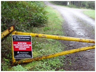
I wanted this story be about success. I've been waiting to write for two years now, working behind the scenes. It should have been a snap, easy-peezy. Just one phone call and the illegal "no trespassing" signs come down, the public is allowed back in, all is operating as intended (and required). Unfortunately, it hasn't quite work out that way.

I discovered that 260 acres of public land on the Toutle River was (is) being improperly restricted. The land is accessed by a legal, written easement "for all road purposes associated with the ownership of the land". Instead, the access road is gated and posted with bold "no trespassing" signs. It should be a simple fix: The land is in public hands and is dedicated to public use. It was given, free of charge, to the local Conservation District by the state of Washington with along with this access road easement. I have a copy of the easement; I have the deed requirements that outline how the land must be used. These include a provision specifically requiring uninterrupted river recreational access. Don't take my word for it. These documents are on the county's property website at the bottom under "conveyances" for everyone to see.
Cowlitz Property Info | Properties Listing Grid (cowlitzinfo.net
I contacted the Conservation District and made presentations. I pointed out all the multiple agency goals for public access to our rivers and public lands. It seemed like such a little thing, an easy no-brainer win for recreation. JUST CHANGE SOME SIGNS. But nothing is simple when dealing with Weyerhaeuser.
It seems the mega-corporation--the largest landowner in the United States--will not allow anyone access on that 260 acres accept their paying clients. All recreationists in the West know about how private land can block public land, giving exclusive access to private interests. This is exactly what is happening here, with the recreational lease-holder of Weyerhaeuser's getting exclusive access to that 260 acres. The Conservation District managing the land (with conflict of interest up to their eyeballs) doesn't want to ruffle the feathers of a powerful corporation that owns nearly half of Cowlitz County. I've called and clawed and complained for two years now. And what outrageous thing am I asking? Change the "No Trespassing" signs on the gate to "non-motorized access allowed", which is the way it was before Weyerhaeuser started their recreation fee program. I haven't ask to open the road to vehicles, or to remove the gate, just modify the sign, and simply allow the public access to public land to walk, bicycle or horseback ride that easement route to public land. But no. Nope. No way. Big W wants to control not only their land, but everyone else's too. The agency, after nearly two years of prodding, reluctantly asked the company about the issue, but was told in a fashion to "sit down and shut up", which they dutifully did. Both the Consevation District and Weyerhaeuser are much more concerned about keeping the public from wandering onto the lease, than the public's right to access public land via a public easement. And consequently, the lease holder gets virtual exclusive access to the public's land.
Since these threatening signs are designed to keep regular hunters and anglers from legally accessing public land, they may actually be a violation of Washington law! (RCW 77.15.210) To paraphrase, it is illegal to harass, intimidate, interfere with or disrupt the lawful pursuit of hunting and fishing. How is posting a legal access route to a river with public land NOT a violation of this law?
So what to do? I'll keep chugging along, bringing the issue to more and more public officials. Maybe someone, somewhere out there cares about the publics' rights, too. If you know of such a person, please pass this on...
UPDATE: The state Department of Transportation, who "gifted" the land to the Conservation District in the first place, doesn't want anything to do with enforcing their deed restrictions. After multiple calls and a request from our state representative, the DOT finally did review the situation. What did they say? The same excuse that the Conservation District is using: The public can SWIM the river to get to the land, so it is technically available for uninterrupted recreation even with the road closed and posted. There is a lesson here for any community that has mitigation put in place to compensate for a harm. Do not trust. Make sure there is a strong enforcement of promises or you will lose.
|
|
June 23, 2020 05:51:07
Posted By Toutle Trekker
|
The region has several different opportunities for visitors to enjoy our great rivers and lakes, with boat launches that range from hard to find primitive coves to full-service launches with ample parking.
Lets start with full service:
Cowlitz River: Al Helenberg Boat launch in Castle Rock. restrooms, shower, life jacket loaner, ample parking and day use fee. Access to Cowlitz River, which is primo for steelhead and salmon. Sometimes in high water its a bit fast for small craft. Directions: From either end of the City of Castle Rock at flashing red light, turn (instead of going straight), cross the Cowlitz River bridge and travel straight to the 4-way stop at Four-Corners, then take right and follow signs. If you get to the high school, you've gone too far.
Kerr Road: WDFW developed boat launch for Silver Lake. Nasty pit-toilet, ample parking with picnic area. Discover Pass required. From Castle Rock follow 504 about 8 miles, look for small brown recreation-type sign at Kerr Road. Follow to end.
Coldwater Lake: non-motorized only. No fee. Nice restroom, area and trails nearby. Floating launch with small beach and limited shore area. Follow 504 to milepost 45.
Toledo: Cowlitz River access with tight but developed boat launch near 505 bridge over Cowlitz River. From SR504 take SR505 to Toledo, or travel North on I-5 to Toledo exits then through town. Launch is near bridge.
Primitive launches: areas where you can launch without any facilities.
Cowlitz River: Cook-Ferry Road/Camelot- From Four-Corners 4-way stop described earlier turn left, follow Westside Highway to Camelot or Cook Ferry Roads. Routes lead to sandbars across from "The Rock" and are popular with plunking and some launching. There is also a very primitive sand road behind the BMX bike track that leads to the shore of the Cowlitz.
Toutle River: WDFW volunteers maintain a four-acre area adjacent to Tower Road bridge for launching small craft and accessing the mainstem Toutle River. Some whitewater folks float from the 504 bridge just outside Toutle to the Tower bridge. Tower Road loops into the Spirit Lake Highway (504) at both ends. Another place for primitive take out/launch is the end of Basie Road, which intersects with Tower Road. The Tower bridge is closer when accessed from the Castle Rock end. Turn near the gas station by the KOA campground.
Silver Lake: Kayaks can launch from Canal Road culverts (see earlier posts) and a small niche near the east end of the boardwalk at Seaquest State Park.
South Toutle River: Harry Gardner Park and 4100 Road. Both offer access to South Toutle River for small, packable boats.
Bridges: Legally, where a public road crosses a navigible river on a bridge, the river may be access from the road right-of-way, although it may not be easy!
Private launches and Boat Rentals: Several businesses at rent boats and/or provide moorage and launching.
Silver Lake Resort: Along SR 504 at milepost 7, this resort has launching, moorage and rental services for everything from a paddleboard to a motorboat. (360)274-6141
Silver Cove Resort: 351 Hall Road. Boat and Kayak rentals on Silver Lake to public (360)967-2057
Streeter's Resort; 120 Lake Road, Silver Lake, Wa. Bumper boat rentals at Silver Lake (360)967-2318
Coldwater Lake: Summer kayak rentals (on hold during COVID)
Rapid Rides, North Toutle River. (360)463-3830 tube ad kayak rentals
|
|
February 23, 2019 01:53:38
Posted By Toutle Trekker
|
Did you know a big-time Hollywood movie was filmed in the Toutle Valley? In 1937 "God's Country and the Woman", a logging-adventure-love story, was filmed in several locations in Cowlitz County. I've seen the movie a few times on classic television, and I made a VHS copy of it once. It's really cool to see the places we locals are all familiar with on the big screen, especially the shots of Spirit Lake and Mount St. Helens from before the eruption. Another famous scene is of the rocky Toutle River Gorge, dubbed "Hollywood Gorge" after the film. Spoiler alert! They created an artificial log jam, blasted it wide open, and ran a train engine into the river all for the movie. My father grew up on the banks of the river here, and as a child, I fished the very near where the action occurred all those years ago.
Today, it is more difficult to see Hollywood Gorge. Much of the land and the main access road to the heart of the Gorge is now posted, but the river remains public. Experienced kayakers and boaters (and I emphasize experienced!) float the Toutle through the Gorge for high adventure during high water. Most whitewater enthusiasts put in at the main Toutle bridge just past Drew's Grocery and float to the takeout on Tower Road. The rapids can be class 4 with high, muddy and log filled waters adding to the adventure and danger. Over the years, commercial rafting company's have offered trips. If you are into this type of thing here's a site with the details: https://www.americanwhitewater.org/content/River/detail/id/2253/
There are also some YouTube videos posted for a "virtual" run down the Toutle.
If you want a view of the gorge from dry land, here are a few places to see it. The first bridge across the Toutle was called Coal Banks Bridge, and it crossed at a narrow, rocky point about a half-mile downstream of the current bridge on Hwy 504. The Coal Banks Bridge was replaced by a new bridge about 1970. When the eruption wiped out the new bridge, the Army Corps of Engineers resurrected the old Coal Banks location and put in a Bailey bridge. After the eruption kids like me rode the school bus across that narrow Army Baily bridge for a few years. (National Geographic magazine photographers even rode with us once.) High in a school bus on the Bailey bridge, you could really get a good view of the roiling water at the heart of the Gorge. I know I wouldn't be going down there in a kayak or raft!
The Bailey bridge was removed when a new post-eruption bridge was built, but the route remains. Park at either end of the old Coal Banks Road gates and walk the old pavement to where the bridge used to cross the river. (Because a state law that prevents counties from giving up road access to waters, these routes are open to the public.) The route on the east side of the new bridge is shorter. This location gives you an idea of the wildness of Hollywood Gorge. Driving along Tower Road, which loops between Castle Rock and Toutle, also provides pull-offs and glimpses of the canyon and Gorge in several places. The WDFW manages the take-out location where Tower Rd. crosses the River. Pull off here to walk down to the water.
|
|
February 9, 2019 09:00:01
Posted By Toutle Trekker
|

Sometimes we tend to overlook great places that are right out the back door. It always surprises me to hear people who live in Cowlitz County but have never been "up the highway" to Johnston Ridge. People come from all over the world to see Mount St. Helens, but sometimes locals don't.
I was that way with kayaking Silver Lake, and what fun I've been missing. It was just a quick trip in a borrowed kayak, but the evening was quiet, the water smooth, and the views and sunset-- stunning.
Here where I went. Take Sightly Road to Canal Road, which swings right. Canal Road drops to single lane with no center lane stripe and heads toward the lake along Hemlock Creek. In the past canals and ponds were dug here for drainage, thus the name. There is a tight parking spot just past the culverts on the right. This is also the "launch". I put in here and followed the main channel west toward the main lake. The vegetation, mostly spirea, willows, and ash trees, holds many signs of wetland life. Birds and beavers are abundant. Just when you think you've run out of room to paddle, you notice that some of the brances have been snipped, creating a narrow tunnel in the brush. Yes, this is the way. Push and pull along, under and through to the other side where the water opens up again, and the lake proper is in sight. Side channels lead to other areas to explore. As darkness neared, I turned around before hitting the main lake, but the return views of Mount St. Helens were spectacular.
|
|
|
|