Welcome to the Toutle Valley!
I'm starting this blog to help visitors find the many things to do around Mount St. Helens and the Toutle Valley. Our area is surrounded by adventure, high and low, but it's sometimes genuinely hard to find information about these special places. Before our volcano erupted, the Spirit Lake Hwy followed the Toutle River all the way to Spirit Lake and Mount St. Helens with easy-to-find adventure around every bend. The route was lined with campgrounds, river access, logging roads, trails open to all, and vast areas to explore.
Today its different--With all the passes, permits, and rules, it's a tangle of red tape to just understand where you can go for a walk. Don't dispair! I know all the secrets... and I might even be asking for your help to make the area more accessible.
Consider this blog your Insider's Guide to the Toutle Valley.
|
January 20, 2024 04:04:23
Posted By Toutle Trekker
|
|
|
|
May 3, 2023 03:21:46
Posted By Toutle Trekker
|
I'm done pussyfooting around. I've teased; I've hinted; I've even written a post or two that touched on the subject. Now I'm ready to jump in head first. I'm going to tell everyone how to open gates to landlocked state land. And I'm going to give you all the links and sources to prove it! I have the passcode, the combination, the Magic Number. Here it is: 1-9-6-7. That's it folks--1967 is the key to unlocking private timber company gates that block public access to public land.

Gates like this one on the 500 Road. It's one of the main access routes to Weyerhaeuser's St. Helens Tree Farm. Maybe you even paid Weyerhaeuser for a permit and key. Despite what the signs warn, "permit required for all access", the 500 Road is a shared road, and the state of Washington has legal access rights on it. Just a few miles past that gate lies 15,000 acres of State DNR land.
So how does "1967" open that gate? It turns out that the 40th legislative session in 1967 was unquestionably the most important for outdoor recreation EVER. Washington was the fastest growing state in the nation. Sprawl was effecting farms, forests, and open space. Governor Dan Evans was concerned about this loss of quality-of-life, and he intended to do something about it. He even gave a special speech to highlight his outdoor recreation priorities. He called for a scenic highway system, protection of the seashore, and broad cooperation between public and private entities. Then he challenged the legislature to do even more...and they did. Many significant laws were passed, including three that effect that gate on the 500 Road.
First, the legislature passed recreational immunity (RCW 4.24.210). For years the old Department of Game, along with large private landowners, had been pushing for a this change that would protect private landowners from lawsuits if they allowed free public recreation. It passed in 1967. Next, the State DNR obtained the legal authority to provide recreation and recreation access routes to public land. (RCW 79.10.140) This law put the DNR squarely in the public access business. And, most importantly, "current use taxation" finally passed in 1967. This was the start of the process to fundamentally change how land is taxed. It was a BIG deal, with a multi-step and multi-year process. The next year, the people would vote to change in the state constitution to allow it. And after that, in the decade that followed, the legislature would refine and tweak how current use taxation would operate for different types of open-space land, like farms, ranches, and forest land. The change had the support of timber companies because it would mean a big tax break for them, but real estate entities lobbied against it, and stated in the 1968 voter's pamphlet that "this is a calculated effort by the major timber companies to shift the burden of real estate taxes to other types of property."
During this long process the timber companies needed to keep the people on their side. Imagine the repercussions if they had started their expensive recreational permits while "current use taxation" was still in its design phase. People would have been outraged! The vote in 1968 would have failed. And the generous tax breaks that passed in the subsequent years would have crashed and burned. Instead, they (wisely) embraced free public recreation. Private landowners heeded Dan Evan's call for cooperation and partnership in outdoor recreation. All through the 1970's and 1980's private timberland was wide open for hunting, fishing, camping, hiking, and biking. This was not a coincidence.
And, most importantly for the 500 Road, the easement language between timber companies and the state of Washington changed virtually overnight. Before the 1967 legislative session, the road easements between these entities have a restrictive clause that limited the use to "land management and administrative activities". After the legislative session, this restricting clause was removed. The easement on the 500 Road was signed in October of 1967, and it has a purpose of using existing roads to "provide access to and from the lands of the parties hereto." PERIOD. No limiting clause tacked onto the end.

The DNR knows all about these broadly worded easements, calling them a legal "grey" area. With the power and influence of the nation's largest landowners threatening them, the agency treats pre- and post-1967 easements the same. They have simply forgotten the deals and promises, concessions and tax breaks, laws and agreements of 1967. We all should be able to use these routes to access public land without being molested by corporate cops or the game wardens in their pocket.
Help Out: Imagine how much public land would be accessible if our leaders confirmed that we could use these routes! Contact Public Lands Commissioner Hillary Franz at the DNR, the Department of Fish and Wildlife leadership, or Governor Inslee's office (which has shown some interest). Write legislators and remind them that the the broad and open wording of post -1967 easements were bought and paid for by the public! Do your own research. Maybe that gate near you that blocks access to public land also has a lost and forgotten easement.
Learn More: Check the history out for yourself, then spread the word.
Lewis County has all their easement online: Lewis County Auditor - Disclaimer (lewiscountywa.gov) The Green River Easement is Auditor File 720413.
Read Governor Evan's speech and all 1967 laws here: Legislative Information Center Floor Journals (wa.gov)
The "current use tax law' is here: RCW 84.33.010: Legislative findings. (wa.gov) Read the legislative intent on forestland taxation, which states that providing "recreational spaces" is part of the reason for the tax break. The 1968 Voter's pamphlet link: https://www.sos.wa.gov/_assets/elections/voters' pamphlet 1968.pdf
DNR Biennial Report (pg 19) 3aae2994-e920-4e2e-8bae-89046ff7d06e (wa.gov) DNR states that these roads are open to public recreational use.
|
|
February 8, 2023 05:32:06
Posted By Toutle Trekker
|
Back when I was a kid, I testified in front of a Colonel Friedenwald of the Army Corps of Engineers in Longview, Wa. My Grandma stood up, too. Cousins, my mother, and other Toutle citizens, bravely testified against a project that was popular in that city. We were fighting to save our river. The Army Corps was proposing a huge dam across the North Toutle River to trap sediment that was washing into the Cowlitz and Columbia Rivers. The dam would irreparably alter the Toutle Valley, force out one of the last homestead families, and cut off salmon and steelhead from vital spawning streams. Yes, the eruption had damaged the river, but we could see, even back then, that the river could heal itself. A local engineer and author, Alden Jones, gave tours to officials to highlight the natural recovery already taking place in the early 1980's. Nature had done it with past eruptions, and it was fully capable of recovery if given a chance.
But the needs of downstream shipping channels and towns were much more important that the future of the upper Toutle watershed.
We put all our efforts into stopping the sediment dam, and (not recognizing our own impotence and insignificance) the Toutle community didn't push for mitigation for the permanent impacts of the dam. The Reagan administration specifically refused to fund any mitigation, so it was passed onto the state and local partners, then ultimately mostly ignored. (see my post Timber Giant Blocks Legal Public Access, June 2021)
Today you can hike across the dam and see first hand the huge sediment plain that was once the Toutle River Valley. My previous post 'sediment dam hike' has the details.
Our fruitless battle was fought before some of the region's salmon, steelhead, and other river-dependent species were listed under the Endangered Species Act. I would like to believe that things would be different today.
We may have a chance to find out. The law that guided the Army Corps is set to be reviewed in 2035 and a new "cooperative" approach is being tried. The idea is to bring all parties together and work toward common goals that take into account community, economic, recreation, habitat and safety needs. The group is managed by the William D. Ruckelshaus center and it is called the SLTCRC: Spirit Lake/Toutle-Cowlitz River Collaborative. I'm not part of the group, but I'm keeping a close watch on their activities. Hopefully, this time around, the future upper Toutle River will not be sacrificed further, but I'm not holding my breath.
April 2023 update: I attended a two day workshop with the group to comment and advocate for recreational access, but am not a part of it...yet. May 5 update: opps, I lied. Now I am involved in a workgroup.
Check it out:
Spirit Lake/Toutle-Cowlitz River Collaborative (SLTCRC) | The William D. Ruckelshaus Center | Washington State University (wsu.edu)
|
|
January 26, 2021 09:17:59
Posted By Toutle Trekker
|
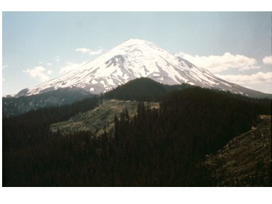
Where is the missing top of Mount St. Helens? Many people think that the top of the volcano was blasted into the sky and became the cloud of ash that circled the world. But that isn't true. The ash that was erupted was "new" material from deep within the earth. The "old" top of Mount St. Helens slid into the Toutle River Valley. This landslide filled the valley up to 300 feet deep with chunks of the old summit. The material consisted of loose layers of rock and ash along with pieces of glacier. The largest mudflow resulted from the de-watering of this huge landslide. These "lahars" inundated all the low lying areas along the Toutle, filled the Cowlitz, and clogged the Columbia River shipping channel.
In response, mass-dredging ensued. The Army Corps of Engineers also quickly built a sediment dam across the North Toutle valley in an attempt to hold the material in place. This first dam (called N-1) was quickly overwhelmed. Over the years, the Toutle River has continued to erode this material downstream, creating big problems for people along the river. The sand along the Toutle and Cowlitz Rivers is old ash and rock from volcanic activity.
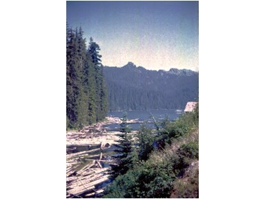
In 1990 the Corps came up with a solution. They would build one huge sediment dam on the North Toutle and stop the erosion! The idea was simple; slow the river down with a shallow lake behind a big dam. The sand drops out, and the water flows out over a spillway. Now towns could be safe. Cowlitz County lifted the building moratorium on mudflow areas and housing developments popped up along our rivers, protected by the dam and higher levies.
Anyone could see, however, that this "solution" didn't stabilize the river or get rid of the landslide material, it just held it in the upper valley a little longer. And that is where we are today. The dam is full, the river above the dam has become a shallow bay of mud, and the Cowlitz River is still clogged with sand. The Toutle has no stable channel, and wanders over the sediment plain, now picking up material and moving it downstream. The spillway on the dam has already been raised once to hold more material, with two more raises planned. Oh, and the dam has no fish ladder. Returning endangered salmon must be trucked around the mess. Baby salmon (smolts) must navigate a web of shallow muddy channels downstream on their way to the ocean. Recently, agencies have tried a few creative ideas to hold sediment in place and to reduce the erosive action of the river. You can see log dikes and piles along the Toutle River in places like Harry Gardner Park or the Mudflow Wildife Area. These features are designed to improve fish habitat and hold the loose material in place long enough for vegetation to establish.
Learn More: https://www.nwp.usace.army.mil/mount-st-helens/overview/
See it: Harry Gardner Park is the best place to see the erosion control and habitat enhancement structures. Along Interstate 5, north of Castle Rock, you may notice large piles of dredge spoils along the Toutle and Cowlitz River. Some of these sites are publicly owned. In the upper Toutle Valley, scan the sediment plain with binoculars for log structure and other erosion control measures. From the Hoffstadt Bridge area the remains of N-1 dam are visible in the valley.

Hike it: From Kid Valley travel east on 504 to Sediment Dam Road, which is actually the old Spirit Lake Highway. Travel about 2 miles to the parking lot at the end. The trail starts past the restroom, and leads to a dam viewpoint and continues to the dam itself. It's a nice walk, half on dirt trail and half on old road.
The view from the dam shows the massive expanse of sediment held in place there. Elk are also common, so be aware. Sometimes herds of elk graze in the grassy field around the dam. If you follow the signs and the old roads, the hike makes a nice 1.2 mile loop.
|
|
June 4, 2020 08:00:00
Posted By Toutle Trekker
|
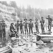 Cowlitz Co. Museum Photo Cowlitz Co. Museum Photo
While sitting here on virus lockdown, I’ve had some time to research the history of the Toutle River. Sometimes the past is key to the present, and nowhere is this truer than in river access. In Washington, the state owns the beds and shores of “navigable” rivers. In the cases where a river has moved, or the state has sold the bed, navigable rivers are still subject to a public easement for river based activities like boating and fishing, even where they flow over private land. This principle is called the “Public Trust Doctrine” and basically it says, the public always has certain rights to waterways, even if the title is privately held.
OK, I’m no lawyer, and some of this is a bit grey-area, but if you want to learn more, check out online “The Public Trust Doctrine and the Coastal Management Zone in Washington” by the state Department of Ecology.
The key question then becomes, “What makes a river navigable?” There are state and federal standards, but the basic rule is that if a river is used, or capable of being used, for useful commerce in its natural condition, then it is a navigable river. The courts decide navigability, and the history of how a river was used at statehood is the deciding factor.
Digging through online newspapers, history books, and numerous Cowlitz Historic Quarterlies, I’ve compiled evidence that the Toutle River was our original highway of commerce. Even locals might be surprised to learn that the region’s first industry wasn’t logging timber for lumber, but was cutting cedar shingle bolts for roofing. By 1883 Castle Rock had its first cedar mill on the banks of the Cowlitz River, and the bolts to supply it, were floated in from the Toutle River. For nearly forty years, the industry was the cornerstone of settlement and development in the Toutle valley. Homesteaders relied on the sale of shingle bolts for nearly all of their hard cash. Laborers lived from one cedar drive to the next. Censuses of the time have listed occupations such as “riverman” and “river driving laborer”. In the 1890’s, when floods flushed bolts out to sea, the economy of Toutle nearly collapsed.
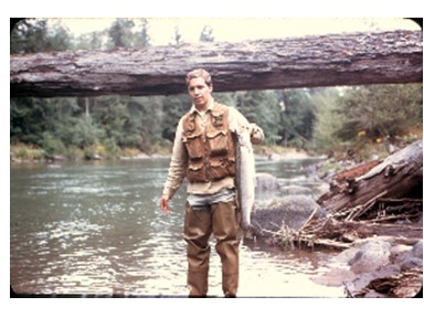
My great-grandfather had a bolt camp in Kid Valley across from where 19 Mile House is today. He lived on-site and employed several workers. Great-grandma was the cook. They cut the cedar into lengths of about 56 inches, and would create a chute of logs to slide the bolts down to the river bank. Each bolt was branded with the owners mark, and with the higher water, the lengths of cedar were floated downstream in annual “bolt drives”. Men walked along the shore, prodding the bolts along and breaking up jams. Because drives could take weeks, a cook boat and blanket boat followed with supplies. I’ve found references to bolt drives from Spirit Lake down the entire North Toutle River, from Soda Springs on Green River, and far up the South Toutle. One famous photo shows 5000 cords (a stack 4’ x 4’x 8’) of bolts in a jam on the South Toutle River! Smaller creeks were also used to move bolts, sometimes with the aid of “splash” dams, which would release water to flush the bolts downstream. To a lesser extent, logs, ties, and specialized 7-foot bolts also took the trip.
By 1930 much of the cedar along the rivers and streams had been cut, and soon logging trains and roads replaced the rivers for getting the wood out. But the history of these forgotten cedar drives could be the gift of the past to the present. Someday a judge or court could affirm that the Toutle River is “navigable” based on this robust history of commerce, ensuring that we can float or fish forever. But that determination has not been made yet.
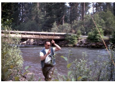
What does all this mean for today? Can you float by: YES, absolutely. Can you walk along the shore? Most probably. Always stay below the high water mark, do not cross private uplands, and for good measure carry a fishing pole and a fishing license, since "fishing" is listed as a right alongside navigation.
See it: The Castle Rock Riverfront Trail passes the location of cedar mills on the Cowlitz River, with an interpretive board about that history. From Exit 49, turn toward downtown Castle Rock, cross the railroad bridge, and take the next right into the trailhead parking lot. The mill site is "downstream" 1/4 mile.
|
|
|
|