Welcome to the Toutle Valley!
I'm starting this blog to help visitors find the many things to do around Mount St. Helens and the Toutle Valley. Our area is surrounded by adventure, high and low, but it's sometimes genuinely hard to find information about these special places. Before our volcano erupted, the Spirit Lake Hwy followed the Toutle River all the way to Spirit Lake and Mount St. Helens with easy-to-find adventure around every bend. The route was lined with campgrounds, river access, logging roads, trails open to all, and vast areas to explore.
Today its different--With all the passes, permits, and rules, it's a tangle of red tape to just understand where you can go for a walk. Don't dispair! I know all the secrets... and I might even be asking for your help to make the area more accessible.
Consider this blog your Insider's Guide to the Toutle Valley.
|
January 28, 2026 07:32:49
Posted By Toutle Trekker
|
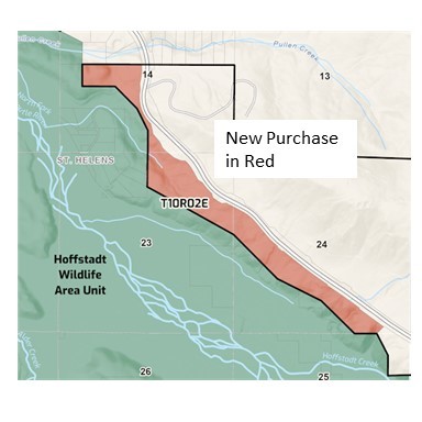
The Washington Department of Fish and Wildlife completed the first 200-acre purchase of Hoffstadt Hills, which is the land wedged between the Spirit Lake Highway and the publically owned Toutle Valley floor. The county clerk's website now shows that this land is owned by the people of the state of Washington, but ownership apps like onX are not updated yet.
Back in the mid-1980's the sediment retention structure (aka sediment dam) was built across the North Toutle River to slow the flow of ash and sand into the lower valley. The funding agreement between state of Washington and the federal government required the State to provide mitigation. Besides the fish trap program, mitigation was mostly ignored. As a first step, the sediment plain was transferred to the WDFW for "habitat and recreation" but without public access for recreation! The WDFW acquired an easement for research, habitat, administration and educational purposes on the 3100 logging road, but it did not, and does not, include recreation. For years a tiny 200-foot wide strip of Weyerhaeuser land blocked access to public land from the Spirit Lake Highway. I lobbied Weyerhaeuser to allow people to hike across that strip for free, but they doubled-down on their permit requirement and specifically added the fee to cross there. I called it the "infamous 200 feet" because this tiny strip blocked access to thousands of acres of public land.
Now the road that passes through that strip is open to the public for non-motorized access, and legal public access to the Mudflow and Hoffstadt Units of the St. Helens Wildlife Area has finally been secured.
|
|
June 6, 2024 10:11:05
Posted By Toutle Trekker
|
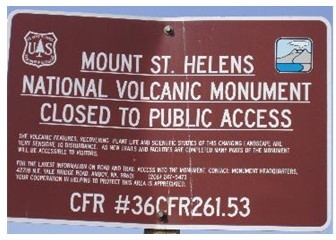
(What I predicted in this post has come true--the USFS resuscitated their previous restrictions in April of 2024). For decades Forest Service land along the Spirit Lake Highway has been heavily posted with government "no trespassing" signs. People hopping out of their cars to get a better view or find a place for their kids to play in the snow, were confronted with these infamous brown signs. The signs are also liberally placed around the visitor centers and along Coldwater Lake. They are still there, but the "administrative closure" behind them has been finally allowed to mercifully die after being kept artificially alive for nearly 30 years.
So for now, I will celebrate. And plan some new adventures.
I've been fighting these improper closures this whole time. (oops, there slips my age!) I started with a petition back in 1993 to allow snow travel on logging roads on land that had just been acquired from Weyerhaeuser. These lands were located between the (then new) Spirit Lake Highway and the original Monument boundary. The public agency acquired them, then immediately posted them closed to the public. These lands were deemed so sensitive that no entry was allowed, despite the fact that since the eruption this land had been salvage logged, replanted, and used as a highway construction site! The USFS said "NO" to my petition. I knew it was simply heavy-handed crowd control. Thus began my long fight to improve access at Mount St. Helens.
I studied the Monument's 1985 management plan, and what I found was stunning: None of the land accessed by the Spirit Lake Highway was ever supposed to be closed like this. In fact, 30,000 acres was improperly (via the back door) placed under an "administrative closure". These type of closures are designed for short term emergencies like fires or floods, but Mount St. Helens used them to circumvent the guidelines of their own plan.
In earlier blogs I hinted that the Forest Service might have let some of its "administrative closures" lapse. This appears to be the case. It turns out, that those longterm closures were illegal. If you check the Forest Service website here Gifford Pinchot National Forest - Alerts & Notices (usda.gov) you can see the current closure orders.
What this means: It is LEGAL to explore the public lands of the Monument, off trail, as long as you stay off the volcano itself and away from the construction sites by Spirit Lake. This is the current condition, but the Forest Service could revert back to more short-term closures if they want. To prevent this, the public must not create user trails or cut switchbacks as they roam. Stay on the trail is still good etiquette in highly popular areas. Off-trail travel away from developed sites is now not illegal. What this means is experienced off-trail hikers can walk from the Spirit Lake Highway to Castle Lake (or Spirit Lake) if they choose. Coldwater Lake is more accessible. The Forest Service, however, doesn't want anyone to really know about this change, so the signs are still there and you will find no PR announcement that 30,000 acres is now open to cross-country travel. I'm the only one talking. (It should be noted that disobeying a sign is still illegal, and the USFS has not removed any signs.)
UPDATE--I hope you all had a chance to explore for the single year that the regulations were lapsed because they are back and as restrictive as ever.
|
|
May 3, 2023 03:21:46
Posted By Toutle Trekker
|
I'm done pussyfooting around. I've teased; I've hinted; I've even written a post or two that touched on the subject. Now I'm ready to jump in head first. I'm going to tell everyone how to open gates to landlocked state land. And I'm going to give you all the links and sources to prove it! I have the passcode, the combination, the Magic Number. Here it is: 1-9-6-7. That's it folks--1967 is the key to unlocking private timber company gates that block public access to public land.

Gates like this one on the 500 Road. It's one of the main access routes to Weyerhaeuser's St. Helens Tree Farm. Maybe you even paid Weyerhaeuser for a permit and key. Despite what the signs warn, "permit required for all access", the 500 Road is a shared road, and the state of Washington has legal access rights on it. Just a few miles past that gate lies 15,000 acres of State DNR land.
So how does "1967" open that gate? It turns out that the 40th legislative session in 1967 was unquestionably the most important for outdoor recreation EVER. Washington was the fastest growing state in the nation. Sprawl was effecting farms, forests, and open space. Governor Dan Evans was concerned about this loss of quality-of-life, and he intended to do something about it. He even gave a special speech to highlight his outdoor recreation priorities. He called for a scenic highway system, protection of the seashore, and broad cooperation between public and private entities. Then he challenged the legislature to do even more...and they did. Many significant laws were passed, including three that effect that gate on the 500 Road.
First, the legislature passed recreational immunity (RCW 4.24.210). For years the old Department of Game, along with large private landowners, had been pushing for a this change that would protect private landowners from lawsuits if they allowed free public recreation. It passed in 1967. Next, the State DNR obtained the legal authority to provide recreation and recreation access routes to public land. (RCW 79.10.140) This law put the DNR squarely in the public access business. And, most importantly, "current use taxation" finally passed in 1967. This was the start of the process to fundamentally change how land is taxed. It was a BIG deal, with a multi-step and multi-year process. The next year, the people would vote to change in the state constitution to allow it. And after that, in the decade that followed, the legislature would refine and tweak how current use taxation would operate for different types of open-space land, like farms, ranches, and forest land. The change had the support of timber companies because it would mean a big tax break for them, but real estate entities lobbied against it, and stated in the 1968 voter's pamphlet that "this is a calculated effort by the major timber companies to shift the burden of real estate taxes to other types of property."
During this long process the timber companies needed to keep the people on their side. Imagine the repercussions if they had started their expensive recreational permits while "current use taxation" was still in its design phase. People would have been outraged! The vote in 1968 would have failed. And the generous tax breaks that passed in the subsequent years would have crashed and burned. Instead, they (wisely) embraced free public recreation. Private landowners heeded Dan Evan's call for cooperation and partnership in outdoor recreation. All through the 1970's and 1980's private timberland was wide open for hunting, fishing, camping, hiking, and biking. This was not a coincidence.
And, most importantly for the 500 Road, the easement language between timber companies and the state of Washington changed virtually overnight. Before the 1967 legislative session, the road easements between these entities have a restrictive clause that limited the use to "land management and administrative activities". After the legislative session, this restricting clause was removed. The easement on the 500 Road was signed in October of 1967, and it has a purpose of using existing roads to "provide access to and from the lands of the parties hereto." PERIOD. No limiting clause tacked onto the end.

The DNR knows all about these broadly worded easements, calling them a legal "grey" area. With the power and influence of the nation's largest landowners threatening them, the agency treats pre- and post-1967 easements the same. They have simply forgotten the deals and promises, concessions and tax breaks, laws and agreements of 1967. We all should be able to use these routes to access public land without being molested by corporate cops or the game wardens in their pocket.
Help Out: Imagine how much public land would be accessible if our leaders confirmed that we could use these routes! Contact Public Lands Commissioner Hillary Franz at the DNR, the Department of Fish and Wildlife leadership, or Governor Inslee's office (which has shown some interest). Write legislators and remind them that the the broad and open wording of post -1967 easements were bought and paid for by the public! Do your own research. Maybe that gate near you that blocks access to public land also has a lost and forgotten easement.
Learn More: Check the history out for yourself, then spread the word.
Lewis County has all their easement online: Lewis County Auditor - Disclaimer (lewiscountywa.gov) The Green River Easement is Auditor File 720413.
Read Governor Evan's speech and all 1967 laws here: Legislative Information Center Floor Journals (wa.gov)
The "current use tax law' is here: RCW 84.33.010: Legislative findings. (wa.gov) Read the legislative intent on forestland taxation, which states that providing "recreational spaces" is part of the reason for the tax break. The 1968 Voter's pamphlet link: https://www.sos.wa.gov/_assets/elections/voters' pamphlet 1968.pdf
DNR Biennial Report (pg 19) 3aae2994-e920-4e2e-8bae-89046ff7d06e (wa.gov) DNR states that these roads are open to public recreational use.
|
|
February 20, 2023 06:29:34
Posted By Toutle Trekker
|
Yesterday, with the snow level around 500 feet and the freezing level just a bit higher, my family headed up the Spirit Lake Highway with our cross-country skis. We got an early start and were up on Elk Rock before the snowplows. There were no parking spots cleared out at the base of Elk Rock, so we carved our own well out of the way of plows. The conditions for skiing were some of the best I've found on Elk Rock, with about a foot of powder on a crunchy base. There are no trails here, just logging roads covered with snow twist up and around Elk Rock. We climbed about an hour up, up, up until the road gets too steep for a downhill wimp like me. If we had kept going, we could have crested the top near the site of an old fire lookout. No snowmobiles had hit the area yet. After a photo and a quick snack, we zoomed (or in my case snowplowed) down in half that time. Conditions were just starting to turn a bit sticky when we got back to the vehicle just after noon. Our trip was lots of fun with good conditions for late winter. Elk Rock is also popular with snowshoers.
Unfortunately, Elk Rock is currently a real missed opportunity for the general public. There are no places at Elk Rock for the public to ski, snowmobile or snowshoe. To just sled or play in the snow, kids crowd the nearby runaway truck ramp. Why? Technically you need a Weyerhaeuser pass to use Elk Rock, even in the winter. Enforcement is probably an area of "don't ask, don't tell" with three feet of snow blocking drive-in access. There are some loopholes here, too. Any signs had been removed and the DNR does have an easement to that old lookout site as well as an isolated rockpit nearby, but besides that, the runaway truck ramp and the Spirit Lake Highway right-of-way are the public access areas above the highway.
A new "secret" opportunity, however, has opened up below the highway in the National Volcanic Monument. I mentioned this a few months back, and now, checking the records, it appears unofficially official. The improper closure order, that made it illegal to step off the trail anywhere along the Spirit Lake Highway, has finally died. Kaput. Gone. But don't expect the Forest Service to tell you this: their no trespassing signs are still up. And the rangers probably haven't even been told that it’s now ok for the public to wander off trail along the old roads or across the landscape. I haven't tried it yet, but snowshoeing cross country from the Castle Lake viewpoint or on other old roads is legal now. Way back in time I did ski on those roads before they were transferred to the Monument from Weyerhaeuser. As soon as the Forest Service got ahold of them--BAM--up goes the no trespassing signs. Now those old roads are a tangle of alder trees, making skiing impossible. Snowshoeing on some of them could be possible, though. I want a report if anyone tries it. (UPDATE: After a year the USFS reinstated the regulations! No more secret opportunity.)
|
|
November 8, 2021 09:10:04
Posted By Toutle Trekker
|
When I grew up, in the 1970's, elk hunting was a lifestyle, a die-hard tradition that was passed down like religion. I remember my first trip to Elk Camp on the 200-line. (Logging roads are numbered and the railroad term "line" denotes a road.) The main camp was fashioned from old railroad ties with an Army tarp roof. It was located in the old growth on Weyerhaeuser land way up high on a ridge. It had a barrel stove and dirt floor. It smelled like smoke and mud and whiskey. I loved it. But things sure have changed...
The eruption of Mount St. Helens impacted this region in unprecedented ways. Big game and big game hunting went for a roller coaster ride. First, the animals were wiped out by the eruption, and in response all hunting stopped. Then, as the fireweed and other good elk food returned, so did the animals. Elk birth rates doubled, and their numbers exploded. By 1985 hunting returned but was limited to draw permits. Success rates approached 100%. Permit applications (and funds generated) soared. Everyone was happy and elk were EVERYWHERE. Herds with 200 elk were common. In the winter, sometimes 1000 elk would gather in the North Toutle valley. All the while, the little trees planted outside the Monument were growing fast, too. 10 years passed, then 20 years, and those little trees started to shade out all that good elk food. By now the animals were clearly overpopulated. In 2006, it all came crashing down. Elk were starving; politicians chimed in with finger pointing; the public was outraged. The state instituted emergency feeding a few times. The population needed to be reduced, so hundreds of cow tags were added. But by now it was too late. Another elk killer--hoof rot--was chewing into the St. Helens herd. (It always amazes me how nature moves faster than human bureaucracy can react.) The state was too slow to start the herd reduction, and too slow to stop it. The elk today must deal with a trifecta of pressures: little feed, many cow tags, and hoof rot. Consequently, now even seing a single elk on a day hunting in the blast zone is a success.
And hunting has changed in big ways. Now families need to purchase permits from Weyerhaeuser just to hunt timberland. Public lands have their own permit requirements, and federal and state lands are often locked behind private pay-for-entry gates. High-tech mapping applications that identify land ownership are needed more than map and compass. Elk are no longer public resources held in trust for the benefit of all forever. Game animals are now commodities being peddled by both public and private interests for the biggest returns. And management of our game is now being sold and subcontracted to interests like Weyerhaeuser. After a day hunting, my family was pulled over by private security and state WDFW enforcement working together for the benefit of Weyerhaeuser's permit system. With three hunters, the state game warden was only interested in the license and tags of the youngest member of the group. Why? Because this teen might need his own $350 Weyerhaeuser permit and his license proved his age!
All is not lost. There are still a few places to hunt by following only public rules on public land. Unfortunately, the public Toutle State Forest is entirely in a draw only area for elk, but it is open for general deer, bear and other game. The WInston Block of DNR land is accessible behind Weyerhaeuser's locked gate on the 1900 road. The DNR has not confirmed that that route is a legal easement that the public can use, so to be safe, have a Weyerhaeuser permit or a very good lawyer if you head to state land via the 1900! While we wait, the Winston Block can be accessed from the north off Highway 12 near Mossyrock. Additional blocks of state land exist along county roads along the Cowlitz/Lewis County property line. Federal land, if you can get to it, is open. Most hunters focus on the Lewis River Valley south of Mount St. Helens.
More information on public land opWDFW Hunt Planner (wa.gov)en to hunting:
|
|
|
|