Welcome to the Toutle Valley!
I'm starting this blog to help visitors find the many things to do around Mount St. Helens and the Toutle Valley. Our area is surrounded by adventure, high and low, but it's sometimes genuinely hard to find information about these special places. Before our volcano erupted, the Spirit Lake Hwy followed the Toutle River all the way to Spirit Lake and Mount St. Helens with easy-to-find adventure around every bend. The route was lined with campgrounds, river access, logging roads, trails open to all, and vast areas to explore.
Today its different--With all the passes, permits, and rules, it's a tangle of red tape to just understand where you can go for a walk. Don't dispair! I know all the secrets... and I might even be asking for your help to make the area more accessible.
Consider this blog your Insider's Guide to the Toutle Valley.
|
July 13, 2026 06:35:09
Posted By Toutle Trekker
|
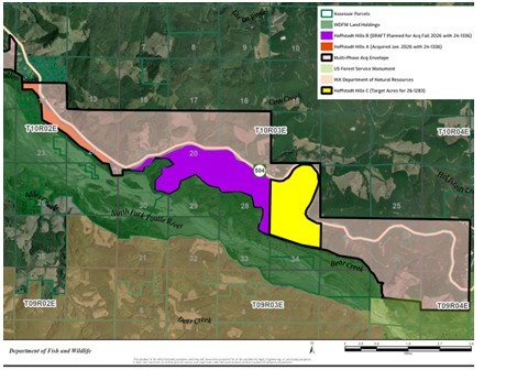
After its first successful purchase of about 200 acres, the WDFW has some leftover money to buy more--if Weyerhaeuser is willing to sell. They are also trying for a new Hoffstadt Hills grant. The plan is to gradually purchase the private land between the Spirit Lake Highway and the mudflow. They also have outlined an area that crosses to the north of the highway. I think there is probably a spotted owl nest near Hoffsadt Bridge on the north side of the highway because there is a patch of old timber there that has not been logged, and there is absolutely no other reason for Weyerhaeuer to let it live this long. In the graphic, the orange strip has been purchased, and the WDFW is currently pursuing the purple and yellow, but anything shaded within the black line could be acquired.
|
|
July 4, 2026 01:36:30
Posted By Toutle Trekker
|
The 1990's were the heydays of Visitor Centers, and no other place embraced these huge buildings more than Mount. St. Helens. The Forest Service kept getting money to build and build, reasoning if they saved the best--Johnston Ridge-- for last, they would keep receiving capital funding. (I personally heard the lead interpreter at the time describe this logic). When the nailing stopped, the USFS had built three massive visitor centers, Weyerhaeuser along with the Washington Department of Transportation had built one, and Cowlitz County another. Each group justified their expenditures by focusing on a different aspect of the volcano’s story. All the centers had gift shops and free entry. Several had food or other amenities.
It couldn’t last. They could get the money to build them, but not to run them.
Currently for USFS operates one center, Johnston Ridge, which is closed due to a washout. Two other centers (Mount St. Helens and Coldwater) have been given to other groups to operate. Cowlitz County sold their Hoffstadt Visitor Center/Restaurant/Gift shop to a church group. Only Weyerhaeuser’s Forest Learning Center is still operating as planned.
As I’ve watched all this unfold, I’ve learned one thing: people want something REAL. When Coldwater Ridge Center first opened with its high-tech touch-screens and the talking manakin, the employees there added a box of rocks with an elk antler to the front desk. This simple display was very popular, and didn’t cost $250,000. I cringe (or cry) when I think of how these funds could have been spent providing visitors with access to the real Mount St. Helens. For example, there are no campgrounds at the Monument, despite that fact that congress directed they be built. Several major trailheads have no legal easements. A connecting trail that linked Mount Margaret to the Green River Trail was never built. Castle Lake was supposed to have a trail access down the old logging road. The Coldwater Valley lacks a planned a boat dock with campsites.
But I digress (and get depressed). Back to the Visitor Center situation today. Three centers are open to the public.
Mount St. Helens Visitor Center: $5 per person entry for adult. The updated exhibits add the Native perspective to the area, while keeping the historic displays. Kids love the walk-through volcano and seismograph exhibits. They show a classic Mount St. Helens movie that is definitely worth the time. Be sure to hike the boardwalk trail, too.
Forest Learning Center: Free. This center presents the story of the eruption told through the eyes of Weyerheuser, the largest private landowner impacted. The company salvage logged and replanted its lands, and is currently logging those trees with mucho-gusto. The original eruption-oriented displays remain, but are complimented with forestry information. Be sure to check out the hands-on Discovery Room and they have a large and diverse gift shop. Elk can often be spotted in the valley below the center
Coldwater Science Center: They honor all federal passes or $5 per car for parking. The ‘return of life’ theme is presented in original displays mixed with new additions. The Science Center is being repurposed for overnight educational groups with big plans to add mini-lodges, a larger campground, and redesigned interior spaces. Currently the site is once again the destination Forest Service visitor center while Johnston Ridge is closed.
|
|
May 4, 2026 11:49:46
Posted By Toutle Trekker
|
I've started exploring the Hoffstadt Hills property, a new addition to the state-owned St. Helens Wildlife Area. This new public acquisition provides an instant boost for hiking, dog walking, and bicycling on ready-made 'trails' aka old logging roads. The property contains at least 2 miles of trail/roads that provide a great place to birdwatch, stretch the legs, or access the mudflow area. The main route parallels the Spirit Lake Highway. The grades are gradual, the roads recently maintained, and the substate is pretty smooth for walking and would work for bicycles or even some strollers. This strip of property connects with Ecopark Resort on the west and Havilah Retreat (the former Hoffstadt Visitor Center) on the east, and the Department of Wildlife Mudflow Unit to the south. More hiking opportunities on old roads and unofficial trails are available once on the Mudflow Unit (that area was closed to protect wintering elk until May 1). Park near the gate where the access road drops toward the mudflow. Currently the land is not signed as public land, but the Weyerhaeuser signs have been removed.
|
|
February 22, 2024 07:52:26
Posted By Toutle Trekker
|
Outside it is wet, drippy, and chilly. What a great time of year to sit and have a tasty snack and a warm latte while browsing the shops of Kalama or Castle Rock. Our region's two small cities are both worth a day of exploration. Recently, I spent the afternoon at the Port of Kalama, where business and recreation co-exist and thrive. The new Mountain TImber Market is just getting started, with goodies like wine, chocolate, coffee, plants and art all for sale in cozy booths lining the edges of this new, sweeping building. Mountain Timber Market The historic and restored Lelooska totem pole is displayed a full story up through the heart of the building. Be sure to go upstairs and watch the video on the restoration. Food carts outside sent barbeque deliciousness wafting on the breeze coming off the Columbia River, which is just a few yards away. Beachcombing, ship and bird watching, walking trails, and an extensive playground round out the options. A person spending the night at the adjacent McMenamin's Kalama Harbor Lodge can use the pedestrian overpass to cross the tracks and duck under I-5 to browse the many unique antique shops in downtown. Dining options also expand (the Chinese restaurant is great!). Nearby to downtown, head to Kress Lake for hiking, fishing, and wildlife viewing. Haydu Park on the Kalama River offers full amenities. The port area is a bit tricky to find off Interstate 5, but your phone or the trail map link below, will lead you there. Cowlitz County Trail Map - Cowlitz EDC
|
|
May 20, 2023 12:48:40
Posted By Toutle Trekker
|
Most rivers and streams open the Saturday before Memorial Day for steelhead and trout fishing. The South Toutle has been open for steelhead for a few weeks, but the North Toutle, mainstem Toutle and Green River open soon, as well as North and Toutle River tributarites (below the sediment dam). Except for the South Toutle River, a single point hook with no bait must be used, and all "wild" trout/steelhead must be released. The South Fork is planted with hatchery steelhead smolts that return from the ocean as fat, yummy, bound-for-barbeque adults. Fishing regulations | Washington Department of Fish & Wildlife. Single hook spinners and flies are a good choice . The South Toutle has good access along the 4100 logging road and at Harry Gardner Park. Remember to stay below the high water mark when traversing private property.

Directions: From the Toutle on SR 504, turn south onto South Toutle Road, which is just across from the gas station. Follow S. Toutle Road over the river, park alongside the road here or at Harry Gardner County Park. To reach the upper river follow S. Toutle another mile to a large gravel road the merges to the right. Take this road and stay right. (If you go under two bridges you have gone too far.) The gravel road is the 4100 logging road, but it may not be marked. Follow the 4100 road along the South Toutle many miles, with plenty of fishing access along the way, to a big yellow gate. Beyond the gate, state DNR land is north of the river, and Weyerhaeuser (permit needed) land is south. Walk-in from here along the shoreline.
The landslide in the upper Toutle mucking up all downstream waters, including the Toutle and Cowlitz Rivers. Coldwater Lake may also be affected (I haven't confirmed that yet, but it is currently inaccessible).
Most lakes are open year round, including Coldwater, Castle and Silver Lake. Currently, only Silver Lake is accessible. Coldwater is closed because of the landslide, routes to Castle Lake are still snowbound, along with most higher elevation lakes. South Lewis County pond, in Toledo, is a good place to "see" big fish, since it has been planted with grass carp. The pond also was planted with WDFW trout derby eligible fish, and two "winners" are still there. The park around the lake is a fun place to spend an afternoon, and it has a covered area, playground, and popular walking path along with the fishing docks. Later in warm weather the water gets mucky and filled with algae. Visit earlier in the year. Kress Lake, near Kalama, also has winning trout left, and is a fun, easy place for kids.
Kress Lake | Washington Department of Fish & Wildlife
South Lewis County Park Pond | Washington Department of Fish & Wildlife
Directions: South Lewis county Pond is located on SR 505 just east of Toledo. The turnoff to the park is just east of the bridge across the Cowlitz River. Park on the left, and walk across to the park. Some of the facilities may be closed, but the park itself is open. This is a good place to take kids because there is a playground, too.
|
|
|
|