Welcome to the Toutle Valley!
I'm starting this blog to help visitors find the many things to do around Mount St. Helens and the Toutle Valley. Our area is surrounded by adventure, high and low, but it's sometimes genuinely hard to find information about these special places. Before our volcano erupted, the Spirit Lake Hwy followed the Toutle River all the way to Spirit Lake and Mount St. Helens with easy-to-find adventure around every bend. The route was lined with campgrounds, river access, logging roads, trails open to all, and vast areas to explore.
Today its different--With all the passes, permits, and rules, it's a tangle of red tape to just understand where you can go for a walk. Don't dispair! I know all the secrets... and I might even be asking for your help to make the area more accessible.
Consider this blog your Insider's Guide to the Toutle Valley.
|
July 13, 2026 06:35:09
Posted By Toutle Trekker
|
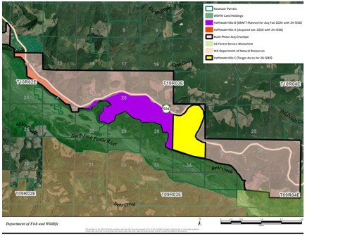
After its first successful purchase of about 200 acres, the WDFW has some leftover money to buy more--if Weyerhaeuser is willing to sell. They are also trying for a new Hoffstadt Hills grant. The plan is to gradually purchase the private land between the Spirit Lake Highway and the mudflow. They also have outlined an area that crosses to the north of the highway. I think there is probably a spotted owl nest near Hoffsadt Bridge on the north side of the highway because there is a patch of old timber there that has not been logged, and there is absolutely no other reason for Weyerhaeuer to let it live this long. In the graphic, the orange strip has been purchased, and the WDFW is currently pursuing the purple and yellow, but anything shaded within the black line could be acquired.
|
|
July 4, 2026 01:36:30
Posted By Toutle Trekker
|
The 1990's were the heydays of Visitor Centers, and no other place embraced these huge buildings more than Mount. St. Helens. The Forest Service kept getting money to build and build, reasoning if they saved the best--Johnston Ridge-- for last, they would keep receiving capital funding. (I personally heard the lead interpreter at the time describe this logic). When the nailing stopped, the USFS had built three massive visitor centers, Weyerhaeuser along with the Washington Department of Transportation had built one, and Cowlitz County another. Each group justified their expenditures by focusing on a different aspect of the volcano’s story. All the centers had gift shops and free entry. Several had food or other amenities.
It couldn’t last. They could get the money to build them, but not to run them.
Currently for USFS operates one center, Johnston Ridge, which is closed due to a washout. Two other centers (Mount St. Helens and Coldwater) have been given to other groups to operate. Cowlitz County sold their Hoffstadt Visitor Center/Restaurant/Gift shop to a church group. Only Weyerhaeuser’s Forest Learning Center is still operating as planned.
As I’ve watched all this unfold, I’ve learned one thing: people want something REAL. When Coldwater Ridge Center first opened with its high-tech touch-screens and the talking manakin, the employees there added a box of rocks with an elk antler to the front desk. This simple display was very popular, and didn’t cost $250,000. I cringe (or cry) when I think of how these funds could have been spent providing visitors with access to the real Mount St. Helens. For example, there are no campgrounds at the Monument, despite that fact that congress directed they be built. Several major trailheads have no legal easements. A connecting trail that linked Mount Margaret to the Green River Trail was never built. Castle Lake was supposed to have a trail access down the old logging road. The Coldwater Valley lacks a planned a boat dock with campsites.
But I digress (and get depressed). Back to the Visitor Center situation today. Three centers are open to the public.
Mount St. Helens Visitor Center: $5 per person entry for adult. The updated exhibits add the Native perspective to the area, while keeping the historic displays. Kids love the walk-through volcano and seismograph exhibits. They show a classic Mount St. Helens movie that is definitely worth the time. Be sure to hike the boardwalk trail, too.
Forest Learning Center: Free. This center presents the story of the eruption told through the eyes of Weyerheuser, the largest private landowner impacted. The company salvage logged and replanted its lands, and is currently logging those trees with mucho-gusto. The original eruption-oriented displays remain, but are complimented with forestry information. Be sure to check out the hands-on Discovery Room and they have a large and diverse gift shop. Elk can often be spotted in the valley below the center
Coldwater Science Center: They honor all federal passes or $5 per car for parking. The ‘return of life’ theme is presented in original displays mixed with new additions. The Science Center is being repurposed for overnight educational groups with big plans to add mini-lodges, a larger campground, and redesigned interior spaces. Currently the site is once again the destination Forest Service visitor center while Johnston Ridge is closed.
|
|
May 4, 2026 12:43:07
Posted By Toutle Trekker
|
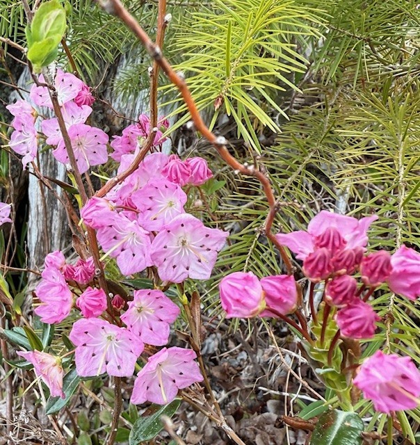
Last year while slogging around the Toutle State Forest in search of elk sheds and unique birds, I discovered a little gem of a swamp (and a saw-whet owl). As a trained botanist, I noticed the unique character of the wetland, with bog laurel, peat moss, abundant shrubs rimmed by remnant old growth and snags. In fact the site hosts two rare plants and several rare communities of plants. Unfortunately, the whole wet meadow was crisscrossed with ATV tire tracks and mudder abuse. The DNR had tried pit traps, signs, and other barriers to keep slobs out of this special area to no avail. One spring day, I was there when a side-by-side came putting right through the center of the meadow, tearing up the unique plants and leaving a long-lasting scar. When confronted, the folks in the UTV couldn't believe they were doing anything wrong. I guess they figured the barriers the DNR had dug to try to keep out motorized vehicles did not mean them. Now the DNR has designated 166 acres of this wetland and some of surrounding land as the Toutle Ridge Fen Nature Area Preserve. The designation should give the DNR more options to enforce the "no motorized vehicles" policy. (Oddly, the DNR logged part of what is now 'protected forever' just last year.)
A bit of an update: The DNR is applying for a grant to "buy" this land (from itself) and permanently protect it, possibly with another designation. It seems odd to have to do this--buy public land to preserve it--but state DNR land is technically owned by a list of beneficiaries (schools, counties, prisons etc) that are entitled to funds generated from those lands. If the land is preserved, and can no longer generate funds, the beneficiaries must be compensated. If you want the details, visit this website, click the project search tab at the top, then search project name "Toutle Ridge Fen." RCO Home Page - RCO Recreation and Conservation Office Home Page
|
|
May 4, 2026 11:49:46
Posted By Toutle Trekker
|
I've started exploring the Hoffstadt Hills property, a new addition to the state-owned St. Helens Wildlife Area. This new public acquisition provides an instant boost for hiking, dog walking, and bicycling on ready-made 'trails' aka old logging roads. The property contains at least 2 miles of trail/roads that provide a great place to birdwatch, stretch the legs, or access the mudflow area. The main route parallels the Spirit Lake Highway. The grades are gradual, the roads recently maintained, and the substate is pretty smooth for walking and would work for bicycles or even some strollers. This strip of property connects with Ecopark Resort on the west and Havilah Retreat (the former Hoffstadt Visitor Center) on the east, and the Department of Wildlife Mudflow Unit to the south. More hiking opportunities on old roads and unofficial trails are available once on the Mudflow Unit (that area was closed to protect wintering elk until May 1). Park near the gate where the access road drops toward the mudflow. Currently the land is not signed as public land, but the Weyerhaeuser signs have been removed.
|
|
April 19, 2024 08:43:44
Posted By Toutle Trekker
|
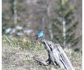
Yesterday I visited Johnston Ridge. How, you ask? The road to the top is washed out and will be closed for YEARS. True, but you can still hike there on the Boundary Trail. Start at the Hummocks Trail near the information board. This loop trail intersects with the west end of the 65 mile long Boundary Trail, which takes off toward Johnston RIdge. Look for the wooden trail sign near an interpretive panel overlooking a meadow near some ponds. Take this trail. It is a 4 mile hike UP the ridge. I climb this several thousand feet each spring to get in shape for the summer season. The snow is nearly gone now, and the main difficulty is some outsloped tread that passes above cliffs and loose rocks. Use hiking poles and have good boots. This is not a beginner trail! After the first big climb you will be on an open ridge that was a clearcut before the eruption. You can tell because of all the rotting stumps sticking out above the ash. This is where the bluebirds live. Look for their sky blue plumage and listen for their charming songs. I saw nearly 30 bluebirds in the area and I took some photos. For an extra treat, on the steep adjacent hillside a family of seven mountain goats were browsing and romping. Beautiful. The sky was the same color as the bluebirds, and the goats matched the snow on Mount St. Helens and the Mt. Margaret Backcountry. I turned around at the Loowit Viewpoint. Round trip took about four hours, nearly 8 miles, and 2000 foot elevation gain. Watch out for those steep, angled sections of trail.
|
|
|
|

