Welcome to the Toutle Valley!
I'm starting this blog to help visitors find the many things to do around Mount St. Helens and the Toutle Valley. Our area is surrounded by adventure, high and low, but it's sometimes genuinely hard to find information about these special places. Before our volcano erupted, the Spirit Lake Hwy followed the Toutle River all the way to Spirit Lake and Mount St. Helens with easy-to-find adventure around every bend. The route was lined with campgrounds, river access, logging roads, trails open to all, and vast areas to explore.
Today its different--With all the passes, permits, and rules, it's a tangle of red tape to just understand where you can go for a walk. Don't dispair! I know all the secrets... and I might even be asking for your help to make the area more accessible.
Consider this blog your Insider's Guide to the Toutle Valley.
|
January 10, 2025 08:37:59
Posted By Toutle Trekker
|
The Mount St. Helens Institute, the Washington Trails Association, and the Forest Service have teamed up to provide a network of linking trails in the Coldwater Lake area. The plan would add another trail that connects the Coldwater Center with the Lake, and then a new linkage to the Hummocks Trail. From there, another obvious need is a link to the South Coldwater Trailhead. The location of this last trail, in particular, is a bit tricky because of all the wetlands and South Coldwater Creek that must be navigated. In total they are proposing 2.7 miles of new trails, with most linkages paved, but the last, steeper portion that drops from the Coldwater Science Center to Coldwater Lake will be unpaved. This is a great and long-overdue improvement and I look forward to seeing these trails actually get built (scheduled for 2026).
Gifford Pinchot National Forest - Home
|
|
June 6, 2024 10:11:05
Posted By Toutle Trekker
|
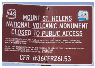
(What I predicted in this post has come true--the USFS resuscitated their previous restrictions in April of 2024). For decades Forest Service land along the Spirit Lake Highway has been heavily posted with government "no trespassing" signs. People hopping out of their cars to get a better view or find a place for their kids to play in the snow, were confronted with these infamous brown signs. The signs are also liberally placed around the visitor centers and along Coldwater Lake. They are still there, but the "administrative closure" behind them has been finally allowed to mercifully die after being kept artificially alive for nearly 30 years.
So for now, I will celebrate. And plan some new adventures.
I've been fighting these improper closures this whole time. (oops, there slips my age!) I started with a petition back in 1993 to allow snow travel on logging roads on land that had just been acquired from Weyerhaeuser. These lands were located between the (then new) Spirit Lake Highway and the original Monument boundary. The public agency acquired them, then immediately posted them closed to the public. These lands were deemed so sensitive that no entry was allowed, despite the fact that since the eruption this land had been salvage logged, replanted, and used as a highway construction site! The USFS said "NO" to my petition. I knew it was simply heavy-handed crowd control. Thus began my long fight to improve access at Mount St. Helens.
I studied the Monument's 1985 management plan, and what I found was stunning: None of the land accessed by the Spirit Lake Highway was ever supposed to be closed like this. In fact, 30,000 acres was improperly (via the back door) placed under an "administrative closure". These type of closures are designed for short term emergencies like fires or floods, but Mount St. Helens used them to circumvent the guidelines of their own plan.
In earlier blogs I hinted that the Forest Service might have let some of its "administrative closures" lapse. This appears to be the case. It turns out, that those longterm closures were illegal. If you check the Forest Service website here Gifford Pinchot National Forest - Alerts & Notices (usda.gov) you can see the current closure orders.
What this means: It is LEGAL to explore the public lands of the Monument, off trail, as long as you stay off the volcano itself and away from the construction sites by Spirit Lake. This is the current condition, but the Forest Service could revert back to more short-term closures if they want. To prevent this, the public must not create user trails or cut switchbacks as they roam. Stay on the trail is still good etiquette in highly popular areas. Off-trail travel away from developed sites is now not illegal. What this means is experienced off-trail hikers can walk from the Spirit Lake Highway to Castle Lake (or Spirit Lake) if they choose. Coldwater Lake is more accessible. The Forest Service, however, doesn't want anyone to really know about this change, so the signs are still there and you will find no PR announcement that 30,000 acres is now open to cross-country travel. I'm the only one talking. (It should be noted that disobeying a sign is still illegal, and the USFS has not removed any signs.)
UPDATE--I hope you all had a chance to explore for the single year that the regulations were lapsed because they are back and as restrictive as ever.
|
|
July 28, 2023 08:59:53
Posted By Toutle Trekker
|
The Gifford Pinchot National Forest, which includes all of the Mount St. Helens area, is asking for comments on its trails system. I have been thinking and discussing and planning and considering trail improvements in the Toutle Valley for decades, so I am pretty excited about this opportunity to engage. However, I have approached the Forest Service before, so I have pretty low expectations about any on-the-ground improvements happening quickly (or at all?) The comment period just closed.
KEY IMPROVEMENT IDEAS
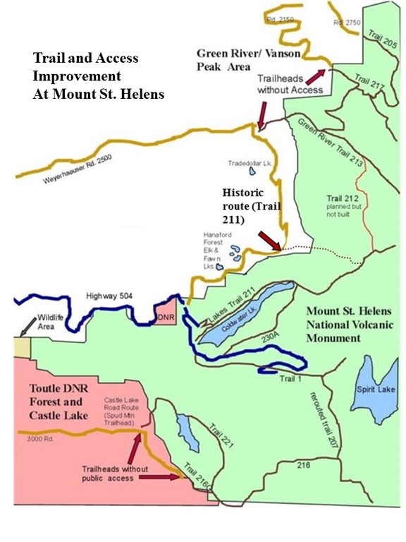
- Official trailheads on the west side of the Monument (213, 217, 216G, Castle Lake road route) NEED public access easements. To access these trailheads you must purchase a $350 Weyerhaeser permit (213 and 217) or rely on the "generosity" of the company to keep roads open (216G and Castle Lake).
- A great new trail could be created parallel to the Spirit Lake Highway just inside the Monument Boundary using old logging roads. The trail would start at Coldwater Lake, link with the Castle Lake and Elk Rock Viewpoints, and then drop down to the Mount St. Helens Wildlife Area in the valley below, all on old logging roads. It could then continue on public land to the sediment dam and exit near the Green River. What a great opportunity for a multi-use trail for hiking, biking, cross country skiing, even horses and ebikes.
- Castle Lake Trail 221 needs to be re-built and re-routed. It's abandoned and unmaintained. The closed and blocked gravel road to the lake needs to be converted to an official trail.
- Re-connect Coldwater Ridge (and the Mount St Helens Institute) with the Mount Margaret backcountry trails system using the Minnie Peak route (historic Trail 212) . Before the eruption several trails here connected to the Mount Margaret area. The existing route along Coldwater Lake and up to Snow Lake is brushy, steep, long, and prone to landslides. The historic route is much more stable. This link would also create a great loop opportunity, and provide a winter snowshoe or crosscountry ski route on logging roads near the Coldwater Complex.
- Build the Falls Creek Trail as planned. Before the eruption THREE trails (212, 246, 213) connected the Green River trails to Mount Margaret. After the eruption, none of these connections were rebuilt. Instead the access was supposed to be replaced by a new trail along Falls Creek, but the trail was NEVER BUILT, leaving the north side of the Monument isolated, and the trailheads landlocked by private timber companies.
|
|
April 20, 2023 01:50:29
Posted By Toutle Trekker
|
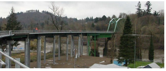
Southwest Washington has a spectacular opportunity to convert the old Columbia & Cowlitz Railroad into a centerpiece trail. This 7-mile route would connect Longview and Kelso with Interstate 5 and Castle Rock at Ostrander. The trail's stunning features would attract visitors from far and wide. Much of the route borders the Cowlitz River, and it crosses on a high bridge with abutting trestles and views galore. This crowning jewel--the bridge across the Cowlitz--is also the main obstacle keeping the trail from becoming a reality. No single agency wants the costs associated with the structure (The line itself would be donated). In a county with high obesity rates and low activity levels, a place to walk, run, bicycle, or enjoy the outdoors is drastically needed. This opportunity of a generation could slip away if people do not care to improve, and are satisfied with the "status quo". A few elected folks are actively against the trail. Yes, there are challenges with such an undertaking, but rail-trails abound in the state and across the country, even in similar communities, bringing economic diversity, health improvements, and quality of life. If you are in Cowlitz County, contact your Commissioner and urge him to support the rail to trail proposal. Do not forget to contact the state senator for the Longview area. Tell these representatives we do not want to be known as an unhealthy and undesireable community. We must start moving toward a better future.
Cowlitz County Board of Commissioners | Cowlitz County, WA - Official Website
Washington State Legislature - Member Email
|
|
March 14, 2023 01:19:53
Posted By Toutle Trekker
|
The final comments have been tallied, and the answer is "More Fees and Higher Fees" to enjoy our public lands. (Is anyone surprised?)
Gifford Pinchot National Forest - Home (usda.gov)
However, it could have been worse. Last fall, I encouraged folks to comment on the ills of fees, especially the chaos and confusion that will come with having two different passes on the stretch of road between Coldwater Lake and Johnston Ridge. The Forest Service seriously wanted a per vehicle parking pass for all the trailheads and a per-person entry pass for the visitor center, or something along those lines--it was so confusing I can't even remember exactly.
That has been toned down a little bit. It looks like they are going to increase the entry fee at Johnston Ridge to $12 per person, and require a NW Forest Pass or America the Beautiful Pass or a $5 daily parking pass at Coldwater Lake, the Hummocks Trail, and the Science and Learning Center. They also want to charge you $7 per person per night to camp in the Mount Margaret backcountry, and they upped the price to $20 per person to climb our volcanoes (Adams and St. Helens). The law that allows these passes actually requires sites to have facilities like restrooms or picnic areas with garbage cans. A few commenters (like me) pointed this out, some with lawyer-like detail, so that might have saved South Coldwater trailhead and a few other places without facilities. I don't know of any plans to add a restroom to the Hummocks Trail as required, but hey, laws usually don't slow the Forest Service bureaucracy down. Oh, and the restroom at Coldwater Lake has been out-of-order since the fall.,,,
P.S. The best way to skip some of the fee hassle is to purchase a yearly $80 America the Beautiful Pass. These can be bought at Johnston Ridge when you arrive. It can be used to get into the Johnston Ridge Visitor Center and as a window parking pass all through the USA at nearly any federal fee site. Better yet, bring up a senior citizen to purchase their lifetime pass, and take grandma to the mountains. Each pass lets in three people (at least it did--I wouldn't be surprised if they got rid of that, too.)
|
|
|
|